
These panoramic views were taken during my three hikes along the whole route of the National Blue Trail since 2004 until today. The views are sorted a western-eastern sequence. If you click in the Contents window on the name of the panoramic view, you will jump directly onto the appropriate photo, or you can surf among the many dozen small views.
The size of the panoramic views are pretty big, it can reach the 3-4 MegaByte, so the download can be even many seconds, but it depends on the speed of the connection. If you draw the cursor on the 800-pixel wide sample pictures, you will see the size of the panoramic views in kiloBytes.
The panoramic views will open on a new page in the original size if you click on the sample pictures. I going to write comments to the panoramic views, what can you see in the pictures, where the interesting places, mountains are commented with their names. I know, the text worsens the overall effect of the panoramic views, so you can open these pictures if you click on the “JPG Extra” icons under the sample picture.
Currently, you can find 68 panoramic views on this page. I wish you a lot of fun with the views.
- Panoramic view from the lookout tower of Óház-tető Hill to Kőszeg town
- 360-degree panorama from the walls of Castle of Sümeg to the castle yars and to the environs
- 360-degree panorama from the Festetics lookout tower to Keszthely and to the Balaton Lake
- Panoramic view from the Kő orra Hill to the Basin of Tapolca and the extinct volcanoes
- Panoramic view from the Szent György-hegy Hill to the Basin of Tapolca and to the volcanoes
- 360-degree panorama from the walls of Castle of Szigliget to the Basin of Tapolca and to the volcanoes
- Panoramic view from the Ranolder Cross (Badacsony Hill) to the Balaton Lake
- Panoramic view from the Csobánc Hill to the Basin of Tapolca and the extinct volcanoes
- Panoramic view from the Eötvös lookout tower to the Basin of Kál
- Panoramic view from the dwelling tower of Castle of Vázsonykő to the village and its environs
- Panoramic view from Castle of Csókakő to the village and its environs
- Winter panoramic view from Castle of Csókakő to the village and the foggy environs
- Panoramic view from the Meleges Hill to Gánt village
- Panoramic view from the walls of Castle of Gesztes to Várgesztes village
- Panoramic view from the Zsigmond-kő Rock to Várgesztes village
- Winter panoramic view from the Zsigmond-kő Rock to Várgesztes village
- 360-degree panorama from the top of Somlyó Hill to the Gerecse Hills
- Panoramic view from the Bajóti Öreg-kő Hill towards the Danube and Esztergom
- Panoramic view from the Kőszikla Hill to its environs
- 360-degree panorama from the peak of Hegyes-kő Hill to its environs
- Winter panoramic view from the side of Hegyes-kő Hill to Tokod village
- Panoramic view from the Kálvária Hill to Dorog town
- Panoramic view from the top of Nagy-szénás Mountain to its surrounding
- 360-degree panorama from the Zsíroshegy Hill to the environs
- Panoramic view from the Zsíroshegy to Pilisszentiván village and Pilis Mountains
- 360-degree panorama from the lookout tower of János Hill (highest point of Budapest)
- Panoramic view from the lookout tower of Kis-Hárs-hegy to Budapest
- Panoramic view from the lookout tower of Nagy-Hárs-hegy to Budapest
- Panoramic view from the Hármashatár-hegy Hill towards east
- Panoramic view from the Hármashatár-hegy Hill towards northwest
- Panoramic view taken at the Teve-szikla Rock
- Panoramic view from the peak of Nagy-Kevély to its environs
- Panoramic view from the fields above Csobánka village to the village and the mountains
- Panoramic view from Dobogókő to the Danube and the Börzsöny Mountains
- 360-degree panorama from the lookout tower of Nagy-Villám to the Danube Bend
- Panoramic view from the lookout tower of Hegyes-tető to the Danube Bend
- 360-degree panorama from the lookout tower of Csóványos to the Börzsöny Mountains
- Panoramic view from the fields of Nógrád village to the castle and the mountains
- 360-degree panorama from the wall of Castle of Nógrád to its environs
- Panoramic view from the top of Nagy-Kő-hegy Hill towards west to the Danube Bend
- Panoramic view from the quarry of Naszály Mountain to the Danube
- Panoramic view from the ridge of Naszály Mountain to the hills of Cserhát
- Panoramic view from the fields above Felsőpetény village
- 360-degree panorama from Castle of Szanda to the hills of Cserhát
- 360-degree panorama from the lookout tower of Major-tető Hill
- Panoramic view from the shore of Lak-völgyi-tó Lake towards the Bél-kő Mountain
- Panoramic view from the Bél-kő Mountain
- Panoramic view from the Őr-kő Mountain
- Panoramic view from the Tar-kő Mountain
- 360-degree panorama from the lookout tower of Bálvány Mountain
- Panoramic view from the fields above Mályinka village
- Panoramic view at the shore of Lázbérci-víztároló
- Panoramic view from the hillside above Kelemér village
- 360-degree panorama from the Karu-fészke-tető Hill
- Panoramic view from the top of rock above the entrance of the Baradla dripstone cave near Aggtelek
- Panoramic view of Rakacaszend village and its environs
- Panoramic view from the fields above Felsővadász village
- Panoramic view from the last hill of Cserehát to the plain of Hernád River and the Zemplén Mountains
- Panoramic view of the Zemplén Mountains taken from Hernádcéce village
- Panoramic view of the Zemplén Mountains from the fields of Mogyoróska village
- 360-degree panorama taken from the wall of Castle of Regéc
- Panoramic view from the peak of Nagy-Péter-mennykő Mountain
- Panoramic view from the Sólyom-kő (Sólyom-bérc) Mountain
- Panoramic view from the stone cross to Castle of Füzér and the Nagy-Milic Mountain
- Panoramic view from Castle of Füzér to the Zemplén Mountains 1
- Panoramic view from Castle of Füzér to the Zemplén Mountains 2
- Panoramic view from the lookout tower of Little-Milic to the Hegyköz Plain and Castle of Füzér
")
Download of the commented version of the picture: 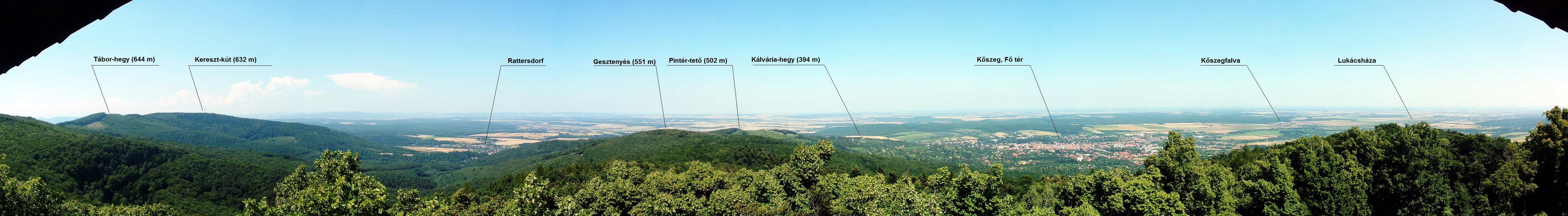
The panoramic picture was taken from the terrace of the lookout tower on the top of the Óház-tető Hill (607 m). The lookout tower is the renovated dwelling tower of an old fort above Kőszeg town on the route of the National Blue Trail. The small villages on the left side of the picture are already in Austria.
Position: N47.381622 E16.503142, the place on the Google Maps: LINK
")
This full 360-degree panorama was taken in the Castle of Sümeg during the “Castle games”. The far extinct volcanoes of Balaton-felvidék already visible on the right side of the picture. The castle is accessible from the route of the National Blue Trail with 20 minutes long walk.
Position: Position: N46.981867 E17.282411, the place on the Google Maps: LINK
")
Download of the commented version of the picture: 
The 360-degree panorama was taken from the Festetics lookout tower standing on the top of the Varsás-hegy Hill (231 m). Keszthely town is visible in the middle of the picture and the forest covered hills of Keszthelyi-hegység Mountains are surrounded it on both sides. We can see the western end of Balaton Lake beside the town. The lookout tower is accessible on the short route of the  from the route of the Blue Trail.
Position: N46.783607 E17.291472, the place on the Google Maps: LINK
")
Download of the commented version of the picture: 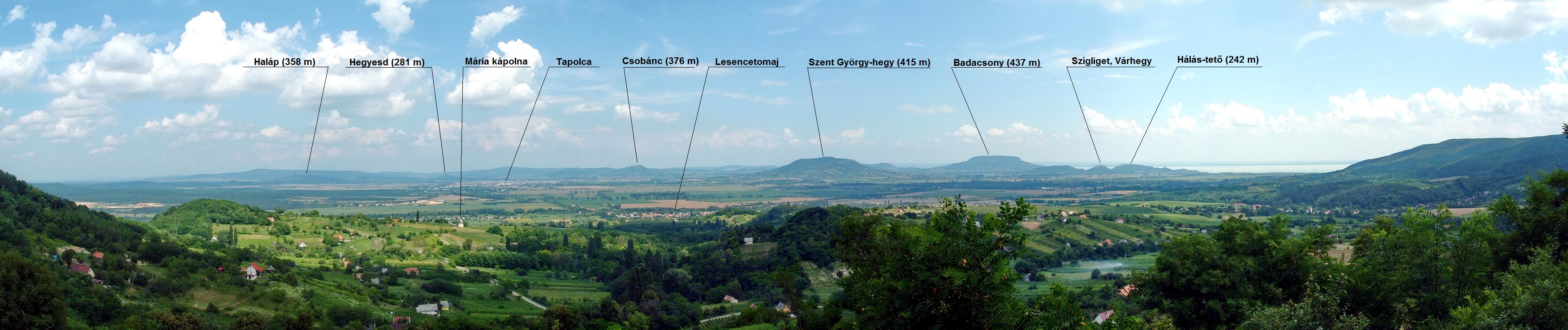
This panoramic photo was taken from the shoulder of the Kő orra Hill, on the route of the National Blue Trail. The extinct volcanoes are visible on the wide plain of Tapolcai-medence Basin. The Szent György-hegy Hill stands in the middle, the Badacsony is visible right from it. The hills of Szigliget stand on the right.
Position: N46.857863 E17.334714, the place on the Google Maps: LINK
")
Download of the commented version of the picture: 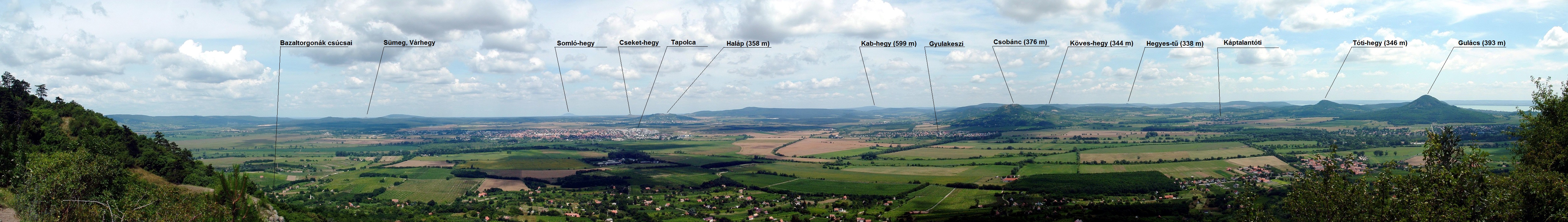
The panoramic photo was taken from the northern side of the Szent György-hegy Hill above the Basalt Orgel towards the wide plain of Tapolcai-medence Basin. Tapolca town lies on the left, and the far Somló-hegy Mountain, the Haláp Hill, the Csobánc Hill, the Tóti-hegy Hill and the Gulács Hill are visible on the plain among the villages.
Position: N46.846090 E17.450811, the place on the Google Maps: LINK
")
Download of the commented version of the picture: 
This 360-degree panorama was taken among the ruins of Castle of Szigliget. The Balaton is visible among the ruined walls of the castle, and the plain of Tapolcai-medence Basin lies on opposite side. The Szent György-hegy Mountain, the Csobánc, the Gulács and the Badacsony stand close to each other on the right.
Position: N46.804366 E17.436467, the place on the Google Maps: LINK
 to the Balaton Lake (Size: 5000 X 801 pixel, 1153 kByte")
The Ranolder Cross stands on the edge of the flat plateau of Badacsony Hill. This panoramic picture was taken from the lookout terrace located exactly under the cross. The Balaton Lake lies at the foot of the Badacsony and the far Castle Hill of Szigliget with the ruins is visible on the right side.
Position: N46.796858 E17.490237, the place on the Google Maps: LINK
")
Download of the commented version of the picture: 
This panoramic picture was taken from the southern edge of the plateau of Csobánc Hill. The big vineyards of the Tapolcai-medence Basin lie the the foot of the hill, the Tóti-hegy Hill, the Gulács Hill and the Badacsony (partly behind the Gulács) stand on the right. The Balaton Lake is still visible from this lookout point!
Position: N46.870471 E17.504479, the place on the Google Maps: LINK
")
Download of the commented version of the picture: 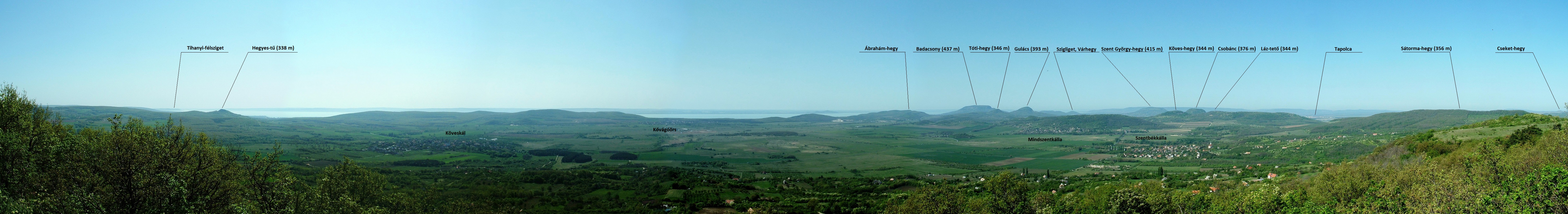
The picture was taken from the top terrace of the Eötvös lookout tower standing on the edge of the Fekete-hegy Hill above Szentbékkálla village. The wide plain of Káli-medence Basin is visible with the small villages, we can see the Balaton Lake among the far hills and the extinct volcanoes stand right from the middle of the picture.
Position: N46.894931 E17.585964, the place on the Google Maps: LINK
")
The panoramic picture was taken from the top terrace of the dwelling tower of the castle. Nagyvázsony village lies on the left of the picture, the small Castle Chapel stands in the foreground. The Kab-hegy Mountain is visible with the TV and radio broadcasting towers in the middle of the photo in the far.
Position: N46.984856 E17.695543, the place on the Google Maps: LINK
")
This panoramic picture was taken from the southern wall of Castle of Csókakő towards the village and the wide plain of the Móri-árok Valley. The hills and plateaus of Bakony Mountains are visible in the background.
Position: N47.360117 E18.277126, the place on the Google Maps: LINK
")
This photo was taken from the same position with the previous panoramic picture at Castle of Csókakő on a winter day exactly at the sunrise. The wide Móri-árok Valley is covered by a thick fog, but the castle is located already above this fog layer.
Position: N47.360117 E18.277126, the place on the Google Maps: LINK
")
This panoramic view was taken from the top of Meleges Hill at the border of Gánt village. The village lies at the foot of the hill and the forest covered plateau of Vértes Mountains gives the background to this picture.
Position: N47.382365 E18.384754, the place on the Google Maps: LINK
")
The panoramic view was taken from the walls of Castle of Gesztes (the castle is closed at present because of a bigger renovation work). Várgesztes village lies in the valley and the rocky forehead of Zsigmond-kő Hill stands behind the settlement. The next panoramic views were taken from that place.
Position: N47.468020 E18.395644, the place on the Google Maps: LINK
")
The panoramic view was taken from the rocky forehead of Zsigmond-kő Hill. Várgesztes village lies in the valley in front of us, we climbed this lookout point from the small rowing lake located in the middle of the photo. Castle of Gesztes is visible on the left side above the roofs of the houses. We can reach this point with a short detour from the National Blue Trail on the steep climbing path of trail marking.
Position: N47.480935 E18.400241, the place on the Google Maps: LINK
")
I took this panoramic view exactly from the same place, than the previous one was taken, but on a winter hike! The houses of the Villapark Várgesztes resort stand on the right side.
Position: N47.480935 E18.400241, the place on the Google Maps: LINK
")
Download of the commented version of the picture: 
This panoramic view was taken from the wide back of Somlyó Hill close to its tallest point. A beautiful round panorama opens from that place to the Gerecse Hill and to the far Buda Hill. We can reach this place on the short path of trail marking.
Position: N47.569894 E18.532141, the place on the Google Maps: LINK
")
Download of the commented version of the picture: 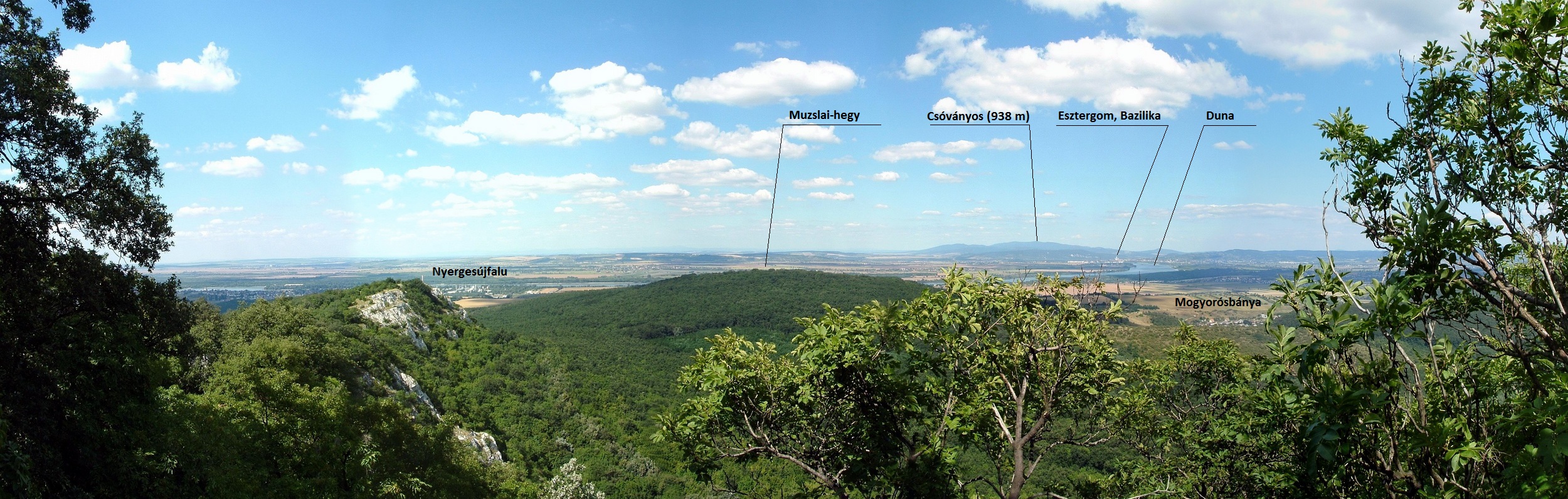
This panoramic view was taken from the rocky eastern side of Bajóti Öreg-kő Hill close to the entrance of Jankovich-Barlang Cave. The cave and this lookout point are accessible from the route of the National Blue Trail on a steeply climbing path and a long flight of stairs. The Danube and the far Esztergom town are visible from that place.
Position: N47.724796 E18.574606, the place on the Google Maps: LINK
")
Winter panoramic view from the rocky eastern forehead of Kőszikla Hill. The vineyards and wine cellars of Tokod village stand at the foot of the hill, and the rocky Hegyes-kő Hill stands on the right in front of the forest covered side of Nagy-Gete Hill. This lookout point is located only in a few dozen steps distance from the route of the National Blue Trail.
Position: N47.722436 E18.614292, the place on the Google Maps: LINK
")
Download of the commented version of the picture: 
This panoramic view was taken from the rocky peak of Hegyes-kő Hill. The Gerecse Hills and the wide plain of the Danube are visible from this place. Tokod village lies exactly at the foot of the hill and the far Esztergom appears behind the houses of the settlement. The forest covered side of Nagy-Gete stands on the right. This peak is about 5 minutes detour from the National Blue Trail.
Position: N47.714367 E18.647411, the place on the Google Maps: LINK
")
This panoramic view was taken from the northern side of Hegyes-kő Hill on a winter hike. The path of the National Blue Trail descends to Tokod village, the rocky peak of the hill is located behind us. The marked route turns right in front of the church and climbs the Nagy-Gete (on the right side of the picture).
Position: N47.715626 E18.649841, the place on the Google Maps: LINK
")
Download of the commented version of the picture: 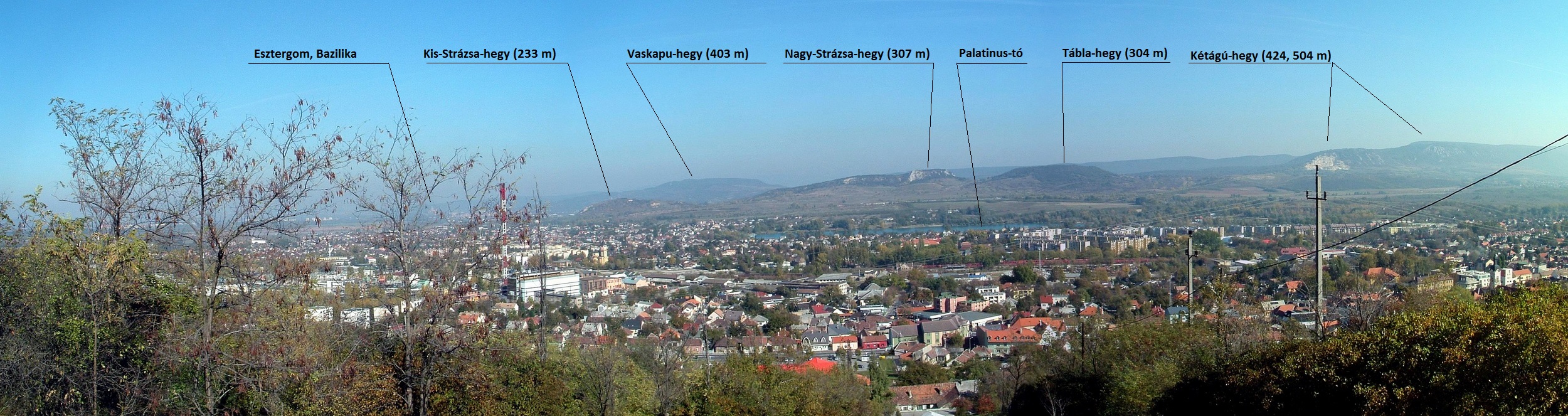
The panoramic view was taken from the peak of Kálvária Hill in Dorog. The small town lies at the foot of the hill, the Palatinus Lake appears behind the houses. The mountains of the northwestern ridge of Pilis Mountains stand in the background. The top of the Kálvária Hill is about a quarter hour long detour from the Trail.
Position: N47.717263 E18.724412, the place on the Google Maps: LINK
")
Download of the commented version of the picture: 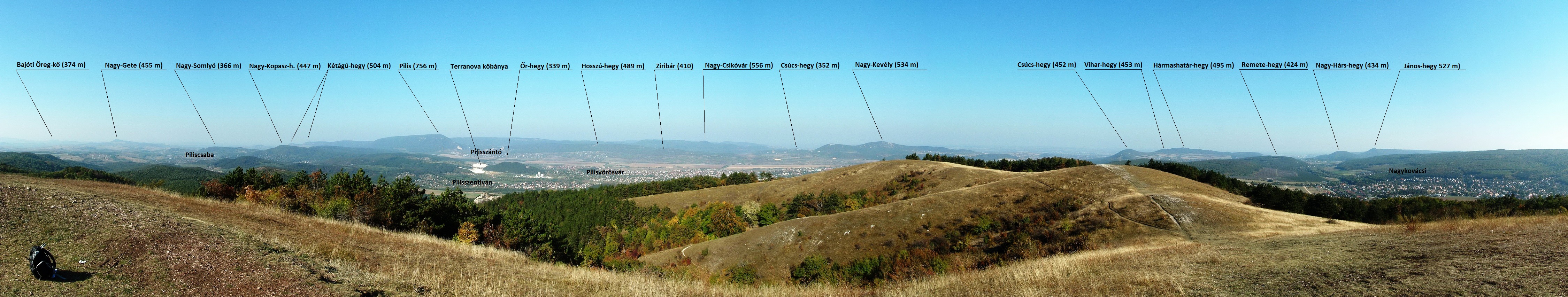
The panoramic view was taken on the 550 metres tall summit of Nagy-szénás Mountain. The peak is a very good lookout point, because the long ridge of the Pilis Mountains and the hills of Gerecse and Buda are equally good visible. The National Blue Trail climbs this peak. This is the first point on the hike where we can see already the houses of Budapest.
Position: N47.590754 E18.871537, the place on the Google Maps: LINK
")
360-degree round panorama from the lookout point of Zsíros-hegy Hill. This alone standing rock is accessibe on the short path marked with from the clearing of the former tourist house of Zsíroshegy. The wide plain of the Valley of Pilisvörösvár lies at the foot of the rock, we can see the whole Pilis ridge from this looout point.
Position: N47.592568 E18.898552, the place on the Google Maps: LINK
")
Download of the commented version of the picture: 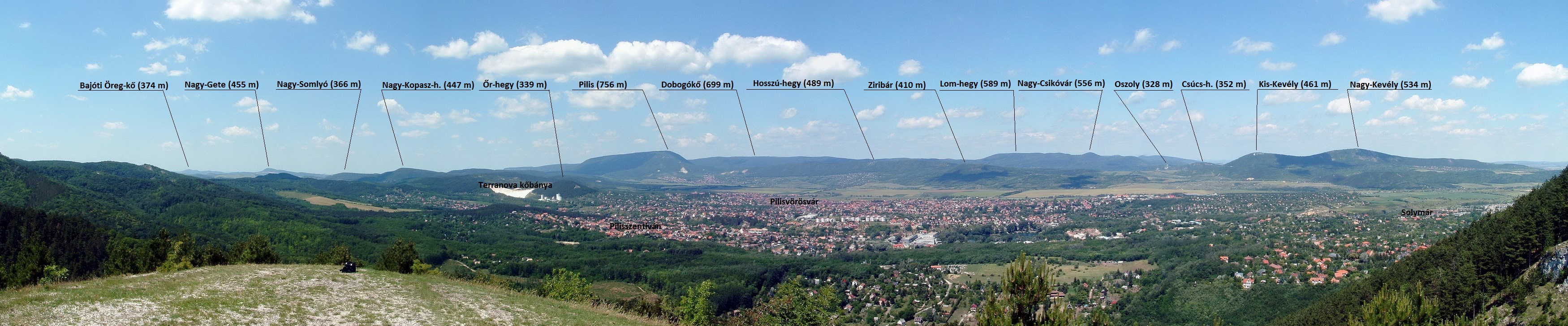
A detail from the 360-degree round panorama of Zsíroshegy towards the Valley of Pilisvörösvár and the Pilis ridge.
Position: N47.592568 E18.898552, the place on the Google Maps: LINK
")
This 360-degree round panorama was taken from the Erzsébet lookout tower standing on the top of the János-hegy Hill (527 m). The János-hegy is the tallest peak of the Buda Hills on the area of Budapest. The capital and all summits of the Buda Hill are good visible from this place. The lookout tower is accessible from Hűvösvölgy with the Children Railway until the stop of János-hegy and on the path of  trail marking.
Position: N47.518189 E18.959298, the place on the Google Maps: LINK
")
This panoramic view was taken from the lookout tower of Kis-Hárs-hegy Hill (362 m). The downtown of Budapest is good visible from this lookout point. The peak is accessible on the route of  and
and  trail markings from Hűvösvölgy. Is is about a half an hour detour from the route of National Blue Trail.
Position: N47.529947 E18.966224, the place on the Google Maps: LINK
")
This panoramic view was taken from the Kaán Károly lookout tower standing on the peak of Nagy-Hárs-hegy Hill (434 m). The downtown of Budapest is good visible from this lookout point. The peak is accessible on the route of trail marking from Hűvösvölgy. Is is about a three quarter hour long detour from the route of National Blue Trail.
Position: N47.533520 E18.955180, the place on the Google Maps: LINK
")
This panoramic photo was taken in 2012 from the rocky summit of Hármashatár-hegy Hill. The lookout point was built only in 2015, which offers round panorama from the peak, earlier hikers could take panoramic photos only in smaller parts from the summit. I took this photo in the eastern direction from the hill towards the Danube and the northeastern part of Budapest.
Position: N47.555511 E18.998647, the place on the Google Maps: LINK
")
This panoramic photo was taken in 2012 from the rocky summit of Hármashatár-hegy Hill. The lookout point was built only in 2015, which offers a round panorama from the peak, earlier hikers could take panorama photos only in smaller parts from the summit. I took this photo in the western direction from the hill towards the field of the gliders and Pesthidegkút quarter of Budapest.
Position: N47.555511 E18.998647, the place on the Google Maps: LINK
")
I took this panoramic photo from the edge of the plateau of Pilisborosjenő village towards the Teve-szikla Rock. We can see the ruins of the scenery Castle of Eger of the movie “Egri csillagok" (in English: Stars of Eger") on the right side of the picture among the bushes. The ruins are easy accessible on that dirt road, which leads on the bottom of the photo at the rocks.
Position: N47.614113 E18.978370, the place on the Google Maps: LINK
")
This panoramic view was taken from the rocky summit of Nagy-Kavély Mountain (534 m). Budapest is visible on the left side of the picture and the forest covered peaks of Buda Hill are in the middle and on the right side of the photo.
Position: N47.622394 E18.984471, the place on the Google Maps: LINK
")
This panoramic view was taken from the dirt road of the wide Csobánkai-nyereg Col towards Csobánka village and the rocky peaks behind the settlement. The forest covered peak of Nagy-Kevély stands on the right side of the picture and the peaks of Visegrádi-hegység Mountains are in the background.
Position: N47.637245 E18.959970, the place on the Google Maps: LINK
")
I took this photo on the lookout terrace of Dobogókő Mountain (699 m). You can see the mountains and hills of the Visegrádi-hegység in the foreground, and the peaks of the Börzsöny are visible in the far, behind the Danube.
Position: N47.719962 E18.898888, the place on the Google Maps: LINK
")
This panoramic view was taken from the Zsitvay lookout tower standing on the top of Nagy-Villám Hill (377 m). You can see the Fort of Visegrád in the middle of the photo, behind the Castle Hill is located the Danube Bend, and the river flows around the most southern mountains of the Börzsöny. The far ridge of Central Börzsöny is visible on the right side in the background.
Position: N47.795554 E18.992213, the place on the Google Maps: LINK
")
This panorama was taken from the top terrace of Julianus lookout tower standing on the top of Hegyes-tető Hill (482 m). This hill stands in the middle of the Danube Bend, the river takes a 180-degree turn around it. You can see Nagymaros village on the closer riverside and Visegrád village with the Castle Hill on the opposite side of the Danube.
Position: N47.783971 E18.933499, the place on the Google Maps: LINK
")
This 360-degree round panorama was taken from the top terrace of lookout tower standing on the top of Csóványos Mountain (938 m). This is the tallest mountain of the Börzösny, it stands in the middle of the Central Börzsöny, surrounded by lower hills.
Position: N47.948960 E18.948262, the place on the Google Maps: LINK
")
This photo was taken from the fields above Nógrád village. The dirt road leads towards the house of the village and the Castle Hill. The northern ridge of Börzsöny Mountains is visible on the left, and the peak of Naszály Mountain appears on the right side of the picture.
Position: N47.902132 E19.026239, the place on the Google Maps: LINK
")
This 360-degree panorama view was taken from the western bastion of Castle of Nógrád. The mountains of Central Börzsöny stand on the right side of the picture and you can see the alone standing Naszály Mountain on the left, behind the wall of the bastion. The forest covered side of Nagy-Kő-hegy Hill stands on its right, behind the houses of Nógrád.
Position: N47.906649 E19.044143, the place on the Google Maps: LINK
")
The panoramic view was taken from the Lokó-pihenő Resting place on the peak of Nagy-Kő-hegy Hill (383 m). The Danube Band and the Castle Hill of Visegrád is visible on the left, Szokolya village lies on the plain in the middle of the photo, and the peaks of the Central Börzsöny appear on the right.
Position: N47.879140 E19.035372, the place on the Google Maps: LINK
")
The panoramic photo was taken from the limestone quarry of Naszály Mountain. You can see the eastern part of the Danube Bend in the picture, Vác town lies on the left on the riverside, the cement factory stands alone on its right almost in the middle, and the mountains of Visegrádi-hegység stand in the background, behind the river. The place, where the photo was taken is accessible on a kilometer long unmarked dirt road from the route of National Blue Trail.
Position: N47.834687 E19.135086, the place on the Google Maps: LINK
")
This panoramic view was taken from the eastern ridge of the Naszály Mountain. The wide Cserhát Hills lies at the foot of the mountain, we can see Ősagárd village right in the middle of the picture. The Börzsöny is still visible on the left.
Position: N47.834003 E19.154870, the place on the Google Maps: LINK
")
This panoramic photo was taken from the fields above Felsőpetény village. The grassy wheel tracks cross this abandoned pasture and descend later in the valley to the village. The next ridge of Cserhát is already visible in the background. We will cross many similar ridges during our hike in the Cserhát Hill.
Position: N47.870594 E19.195023, the place on the Google Maps: LINK
")
This 360 panoramic view was taken from the ruins of Castle of Szanda standing on the eastern peak of Szanda-hegy Hill (529 m). We are standing here in the middle of Cserhát Hill, the small villages are located in the valleys among the hills.
Position: N47.911399 E19.422367, the place on the Google Maps: LINK

This 360-degree panorama picture was taken from the lookout tower of Major-tető Hill above Szarvaskő village. The houses of the settlement are visible in the middle of the photo, and the narrow valley leading between the Mátra an Bükk Mountains. The Mátra lies on the left and the Bükk is located on the right side of the photo.
Position: N47.984218 E20.334586, the place on the Google Maps: LINK
")
This panoramic view was taken on the shore of the Lak-völgy-tó Lake above Bálapátfalva village. We can see the side of the Bél-kő Mountain in the background, a big limestone quarry worked in its side in the 20th century, and a remarkable amount of the mountain was removed and carried to the close cement factory. Now the whole area of Bükk Mountains is a nature reserve.
Position: N48.059257 E20.368436, the place on the Google Maps: LINK
")
This panoramic view was taken from the limestone quarry of Bél-kő Mountain. The whole top of the mountain was removed and carried to the cement factory, which buildings are visible on the right side of the picture. The small Lak-völgyi-tó Lake is located in the right-bottom corner of the panoramic view. We can reach the lookout point by 20 minutes long walk on the path of and trail markings from the route of National Blue Trail.
Position: N48.045674 E20.382233, the place on the Google Maps: LINK
")
This panoramic view was taken from the top of Őr-kő Mountain. We can reach this lookout point by 10 minutes long walk on the path of trail markings from the route of National Blue Trail.
Position: N48.050371 E20.408030, the place on the Google Maps: LINK
")
This panoramic photo was taken from the top of Tar-kő Mountain. We can reach this lookout point with a few dozen steps long walk on the short path of trail markings from the route of National Blue Trail.
Position: N48.056252 E20.461267, the place on the Google Maps: LINK
")
This panoramic photo was taken from the top level of the lookout tower standing on the top of Bálvány Mountain. The lookout tower is accessible with a quarter hour long walk on the path of trail markings from the route of National Blue Trail.
Position: N48.056252 E20.461267, the place on the Google Maps: LINK
")
This panoramic photo was taken from the fields above Mályinka village in 2012. Mályinka village lies in front of us, and a small detail of the Lázbérci-víztároló Reservoir is visible in the middle of the picture among the far hills. A wooden lookout tower was built on this place a few years ago.
Position: N48.149035 E20.492386, the place on the Google Maps: LINK
")
This panoramic photo was taken from the old asphalt road leading on the shore of the reservoir. The route of the National Blue Trail leads with a few dozen steps higher, on the new road in the forest, but it is more interesting to walk on this asphalt strip until it disappears under the surface of the lake.
Position: N48.197645 E20.471180, the place on the Google Maps: LINK
")
This panoramic photo was taken from the asphalt road leading from Putnok to Kelemér village. The road takes big hairpin bends on the hillside, but the path of the National Blue Trail cuts off these curves while descends into the village. Kelemér lies in the valley and the grassy Borsod Hills stand in the background.
Position: N48.353347 E20.438678, the place on the Google Maps: LINK
")
This panoramic view was taken from the ridge of Karu-fészke-tető Hill. We are surrounded by the mild hills of Borsod, the National Blue Trail leads on the hardly visible wheel tracks in the high grass of the big pasture.
Position: N48.375072 E20.444676, the place on the Google Maps: LINK
")
This panoramic photo was taken from the top of that limestone rock, which towers above the entrance of Baradla Dripstone Cave of Aggtelek. The National Blue Trail climbs this rock on stairs and steep promenades, and touches this lookout point. The building of Cseppkő Hotel stands on the left, the car park is located under our feet, and the mild Borsod Hills are in the background.
Position: N48.471741 E20.495455, the place on the Google Maps: LINK
")
This panoramic picture was taken from that stony road, which leads from Rakacaszend village among the hills of Cserehát. The settlement lies in the valley, we can see the 700 years old church of the village at the end of this road.
Position: N48.455847 E20.841492, the place on the Google Maps: LINK
")
This panoramic picture was taken on the upper edge of the cultivated fields above Felsővadász village. The bell tower of the church is still visible on the left and the mild hills of Cserehát stand in the background. The far ridge of Zemplén Mountains is already visible in the middle of the picture on the horizon.
Position: N48.375780 E20.937000, the place on the Google Maps: LINK
")
I took this panoramic view from the most eastern ridge of Cserehát Hills towards the wide plain of Hernád River and the western ridge of Zemplén Mountains, which stands in the background. You can see the far Castle of Boldogkő standing on a lower hill in front of the mountains, exactly in the middle of the photo.
Position: N48.355992 E21.084458, the place on the Google Maps: LINK
")
This panoramic view was taken from those wheel tracks, which cross the cultivated fields between Hernádcéce village and the railway stop of Boldogkőváralja village. Castle of Boldogkő stands on a smaller hill left from the road (it is in the shade of the clouds) and the peaks of Zemplén Mountains stand in the backround.
Position: N48.347907 E21.193699, the place on the Google Maps: LINK
")
This panoramic picture was taken on the pasture at the upper end of the valley of Arka-patak Brook. The grassy field is located on the hillside, the brook flows in front of us, among the trees and the peaks of Zemplén Mountains stand in the background. Castle of Regéc appears on the right, above the trees.
Position: N48.373435 E21.311566, the place on the Google Maps: LINK
")
This 360-degree round panorama was taken from the southern bastion of Castle of Regéc. Mogyoróska village is located in the middle of the picture and you can see Regéc village on the right, above the ruined walls. The mountains of Zemplén stand in the background. This photo was taken still before the partly renovation of the castle.
Position: N48.378080 E21.344144, the place on the Google Maps: LINK
")
The panoramic photo was taken from the rocky summit of Nagy-Péter-mennykő Mountain about the peaks of Zemplén. Castle of Füzér stands left from the middle, in the far, at the foot of the Nagy-Milic Mountain, and the small group of Sátor-hegyek (in English: Tent Mountains) stand on the right.
Position: N48.419605 E21.387574, the place on the Google Maps: LINK
 Mountain (Size: 7000 X 1474 pixel, 3244 kByte)")
The panoramic photo was taken from the rocky summit Sólyom-kő (in English: Falcon Rock) about the summits of Zemplén. Castle of Regéc is still visible on the right side of the picture.
Position: N48.398090 E21.404107, the place on the Google Maps: LINK
")
The panoramic photo was taken from the stone cross of a grassy hilltop between Füzérkomlós and Füzér villages. Castle of Füzér stands on the top of the Castle Hill, the houses of the settlement are visible at the foot of the hill. The peaks of the Milic group give the background of the picture.
Position: N48.525205 E21.457859, the place on the Google Maps: LINK
")
This panoramic photo was taken from the stony path leading to the gate of Castle of Füzér. It is interesting, that we can see the shadows of the castle on the forest covered side of Őr-hegy Mountain in the middle of the picture. The waving plain of Hegyköz lies on the right side with Füzér village. The cableway was built already to the renovation of the castle to carry the materials.
Position: N48.542210 E21.459990, the place on the Google Maps: LINK
")
This panoramic view was taken from the ruined walls of Castle of Füzér in 2011. The walls of the castle were renovated in the 2016-2017, so I think, now you can see this panorama only through the windows. The old walls stand on the left side and a wide panorama opens to the plain of Hegyköz and Füzér village on the right side of the picture.
Position: N48.542210 E21.459990, the place on the Google Maps: LINK
")
This panoramic view was taken from the top of the lookout tower standing on the top of Kis-Milic Mountain. Castle of Füzér is visible already deeply below us on the border of the plain of Hegyköz, which is surrounded by the mountains of Zemplén. We walk here already the last kilometers of the National Blue Trail, we will reach Hollóháza village and the eastern trailhead at the the foot of this mountain.
Position: N48.573174 E21.460827, the place on the Google Maps: LINK
| The name of the hosting provider: | Port Kft. |
| The postal address of the hosting provider: | 9200 Mosonmagyaróvár, Szent István király út 60. |
| E-mail address of the hosting provider: | info@webtar.hu |
| The name of the author and editor of the website: | Horváth Béla |
| E-mail address of the author and editor: | horvabe1959@gmail.com |
| The information on this website is true and complete to the best of the author's knowledge. All recommendations are made without guarantee on the part of the author. The author disclaims any liability in connection with the use of this information. | |
 Creative Commons license: Attribution-NonCommercial-NoDerivatives 4.0 International Creative Commons license: Attribution-NonCommercial-NoDerivatives 4.0 International | |
| Please read the Cookie Policy of this website! It contains important information! | |